Exploring The Secrets Of Professional Land Surveyors
Reyaa Agarwal
Last Updated: October 4, 2023
Jump to Section
Enter the fascinating world of professional land surveyors—the unsung heroes who navigate the land and unveil its secrets. In this blog, we’re delving into the exciting realm of land surveying, where skilled professionals combine science, technology, and a dash of adventure to map out the world around us. Get ready to unravel the mysteries of surveying as we uncover their tools, techniques, real-life stories, and the vital role they play in shaping our environment. So, grab your compass, put on your explorer’s hat, and let’s embark on a captivating journey with professional land surveyors!
The Art Of Measuring: Unveiling The Tools Of The Trade
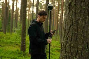
Ever wondered how land surveyors measure distances, angles, and elevations with astonishing accuracy? They have a whole arsenal of tools at their disposal! From the trusty total station to the cutting-edge global navigation satellite systems (GNSS) and unmanned aerial vehicles (UAVs), these professionals employ an impressive array of instruments to capture precise data. Whether it’s theodolites, laser scanners, or ground-penetrating radar, land surveyors blend modern technology with time-tested methods to uncover the secrets hidden beneath the earth’s surface. So, put on your surveyor’s boots and let’s dive into the fascinating world of measurement!
Mapping The Territory: Crafting Accurate And Detailed Land Surveys
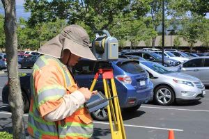
Imagine creating a map that accurately represents the features and boundaries of a vast piece of land. Land surveyors are the cartographic wizards who bring these maps to life. They meticulously collect data, analyse legal documents, and apply mathematical principles to create precise and detailed land surveys. Using specialised software and cutting-edge techniques like photogrammetry and lidar, they transform raw data into visual representations of our physical world. These maps serve as essential references for urban planning, infrastructure development, and environmental management. So, let’s unravel the art of mapping as we uncover the secrets of professional land surveyors.
Unveiling Hidden Histories: Archaeology And Land Surveying
Land surveyors are not just masters of measurement; they also play a crucial role in uncovering hidden historical treasures. Through archaeological surveys, these experts collaborate with historians, archaeologists, and heritage preservation organisations to explore the past buried beneath the ground. With their expertise in understanding the landscape and identifying potential archaeological sites, land surveyors contribute to the discovery and preservation of cultural heritage. They employ advanced techniques like geophysical surveys and ground truthing to reveal ancient structures, burial sites, and other artefacts that shed light on our history. Join us on a journey to unmask the mysteries of the past.

Navigating Challenges: Tales From The Field
Being a land surveyor is no walk in the park. These intrepid professionals face a multitude of challenges in their quest to map and navigate the land. From harsh weather conditions and rugged terrains to dealing with property disputes and encountering unexpected obstacles, they must adapt and problem-solve on the go. Imagine capturing accurate data while battling through thick forests, scaling steep mountains, or wading through swamps! Through their determination, resourcefulness, and love for adventure, land surveyors overcome these obstacles to deliver accurate results. Join us as we delve into the thrilling tales of the field, where every survey is an adventure.
Beyond Boundaries: Surveying The Digital Landscape
The world of land surveying is evolving rapidly, and professionals are embracing digital technologies to revolutionise their field. From 3D modelling and virtual reality to Geographic Information Systems (GIS) and cloud-based data management, land surveyors are harnessing the power of digital tools to enhance efficiency, accuracy, and collaboration. They can now seamlessly integrate data from various sources, analyse complex spatial information, and visualise landscapes in ways that were once unimaginable. So, let’s explore the intersection of land surveying and technology as we navigate the digital landscape together.
Becoming A Professional Land Surveyor With Mentoria!
You’ve journeyed through the captivating world of professional land surveyors, gaining insights into their tools, mapping techniques, archaeological contributions, field experiences, and the digital frontier. These skilled individuals, armed with precision instruments and an adventurous spirit, shape our understanding of the land and ensure the sustainable development of our communities. So, the next time you stumble upon a map or gaze at a breathtaking landscape, remember the dedicated professionals who have meticulously crafted it. It’s time to appreciate the unsung heroes of land surveying and their profound impact on our world. Happy exploring!
We’re here to provide you with all the help! Kick-start your journey with Mentoria and discover the right fit for you. Feel free to call us to speak to our career mentors and choose the right guidance plan that suits your needs.
Mentoria’s career guidance programme enables you to choose your perfect fit from 3 streams, 850+ courses, and 12,000+ careers, and discover what will bring out the best in you.